

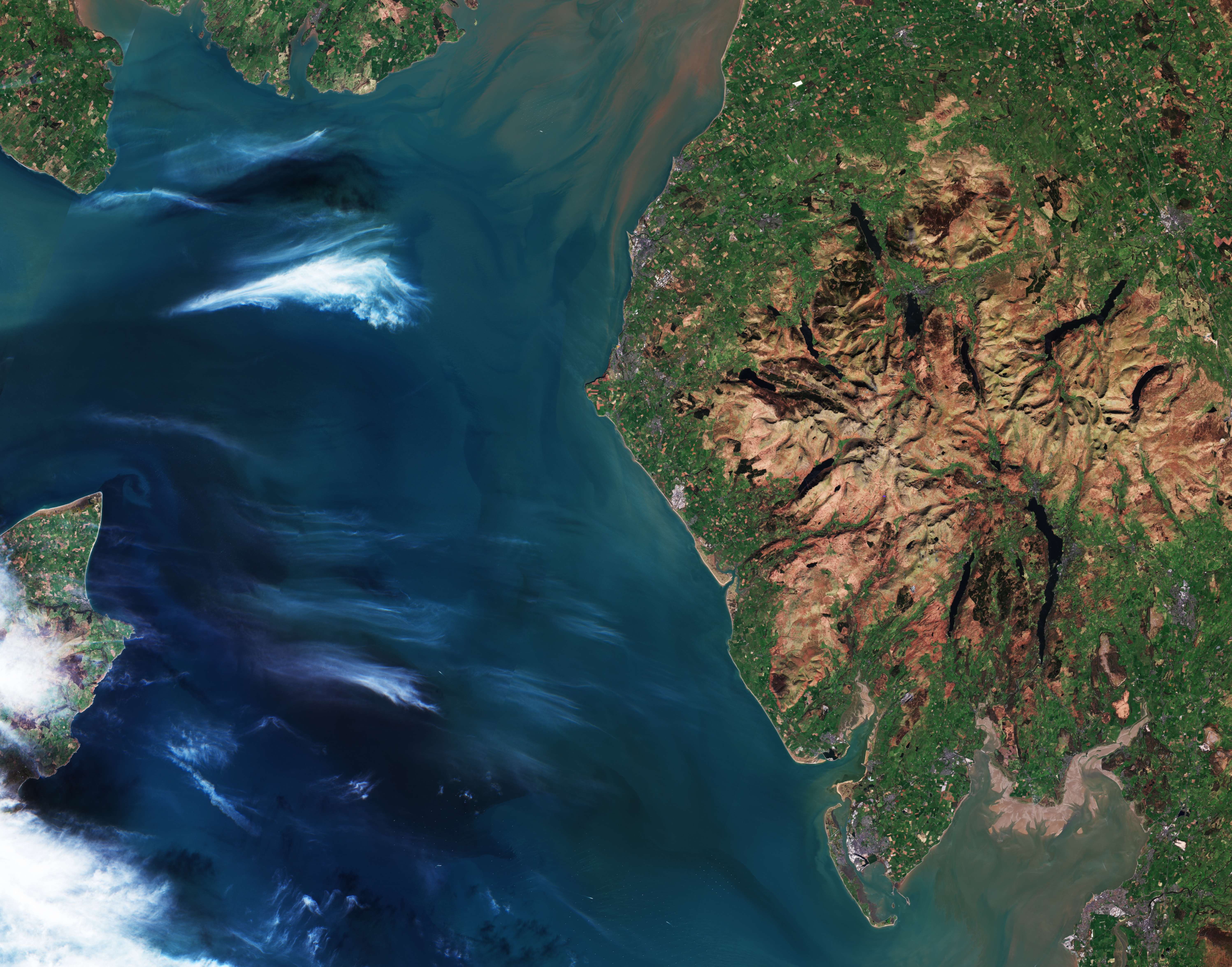
Il variegato paesaggio del Lake District in Inghilterra è mostrato in questa immagine catturata dalla missione Copernicus Sentinel-2.
Situato nel nord-ovest dell'Inghilterra, nella contea di Cumbria, il Lake District è modellato da un mix armonioso di diverse morfologie naturali e si estende fino alla costa del Mare d'Irlanda, di fronte all'Isola di Man, parzialmente visibile all'estrema sinistra dell'immagine. Laghi, colline, valli, boschi, insediamenti e terreni agricoli si combinano per dare vita al più grande parco nazionale dell'Inghilterra, che è stato designato Patrimonio dell'Umanità dall'UNESCO nel 2017.
Come vediamo nell'immagine, il Lake District presenta un nucleo montuoso approssimativamente circolare, profondamente scavato da valli di origine glaciale, che nelle loro cavità ospitano laghi lunghi e stretti. Nella regione si trova la vetta più alta d'Inghilterra, lo Scafell Pike, che raggiunge un'altitudine di 978 m. In una giornata limpida, la vista può spaziare dalle Galloway Hills in Scozia alle Mourne Mountains nell'Irlanda del Nord, così come l'Isola di Man, ed Eryri (Snowdonia) in Galles.
Come suggerisce il nome, l'area ospita i principali laghi d'Inghilterra, tra cui il più grande - il Windermere - la cui forma allungata può essere riconosciuta a sud del massiccio centrale. Accanto al Windermere si trova il Coniston Water e più ad ovest si trovano la valle di Wasdale ed il Wastwater, il lago più profondo dell'Inghilterra.
A nord-ovest del Wastwater si trova il Derwentwater, costellato di isole boscose e più ad est si trova il Ullswater, il secondo lago più grande della regione, noto per i narcisi che hanno ispirato la famosa poesia di Wordsworth che porta lo stesso nome.
Mentre le colline più alte - note anche come alture - sono principalmente rocciose, i boschi nativi decidui si trovano su molti dei pendii più bassi e più ripidi. L'agricoltura estensiva e i terreni agricoli possono essere visti più in basso intorno alle montagne, intervallati da villaggi ed insediamenti, che appaiono come zone grigie.
Il Lake District ospita anche vari habitat d'acqua dolce, come paludi, zone umide lacustri, brughiere costiere, dune e una serie di estuari, tra cui il Morecambe Bay, visibile nell'angolo in basso a destra dell'immagine. Con una superficie di 310 kmq, la baia di Morecambe è la più grande espansione di distese fangose e sabbiose intertidali del Regno Unito e supporta una ricchezza di fauna selvatica, con abbondanza di uccelli e specie marine.
Zoomando al largo della costa della baia di Morecambe, le turbine di diversi parchi eolici offshore si stagliano come punti bianchi nell'acqua del Mare d'Irlanda.
Scarica immagine HiRes (27,42 MB - .JPG)
Scarica immagine HiRes (322,29 MB - .TIF)
---
Lake District, UK
The varied landscape of England’s Lake District is featured in this image captured by the Copernicus Sentinel-2 mission.
Located in northwest England in the county of Cumbria, the Lake District is shaped by a harmonious mix of several natural landforms, and extends to the coast of the Irish Sea, facing the Isle of Man, partly visible in the far left of the image. Lakes, hills, valleys, woodland, settlements and farmland combine to give life to England's largest national park, which was designated a UNESCO World Heritage Site in 2017.
As we see in the image, the Lake District features a roughly circular core of mountains, deeply carved by valleys of glacial origin, hosting long, narrow lakes in their hollows. The region is home to England’s highest peak, Scafell Pike, which reaches an elevation of 978 m. On a clear day, the view can span from the Galloway Hills of Scotland to the Mourne Mountains in Northern Ireland, as well as the Isle of Man, and Eryri (Snowdonia) in Wales.
As the name suggests, the area is home to the principal lakes of England, including the largest, Windermere, whose elongated shape can be seen south of the central massif. Next to Windermere is Coniston Water and further west are Wasdale valley and Wastwater, the deepest lake in England.
Northwest of Wastwater lies Derwentwater, studded with wooded islands, and further east is Ullswater, the second largest lake in the region, known for the daffodils that inspired Wordsworth’s famous poem of the same name.
While the higher hills – also known as fells – are mainly rocky, deciduous native woodland occurs on many of the lower, steeper slopes. Extensive agriculture and farmland can be seen lower down around the mountains, interspersed with villages and settlements, which appear as grey areas.
The Lake District is also home to varied freshwater habitats, such as mires, lakeshore wetlands, coastal heath, dunes and a number of estuaries, including Morecambe Bay, visible in the bottom right corner of the image. Covering an area of 310 sq km, Morecambe Bay is the UK’s largest expanse of intertidal mudflats and sand and supports a wealth of wildlife, with abundant bird and marine species.
Zooming in off the coast of Morecambe Bay, the turbines of several offshore wind farms stand out as white dots in the Irish Sea water.
[Credits: contains modified Copernicus Sentinel data (2025), processed by ESA - Translation: Gianluca Pititto]
