

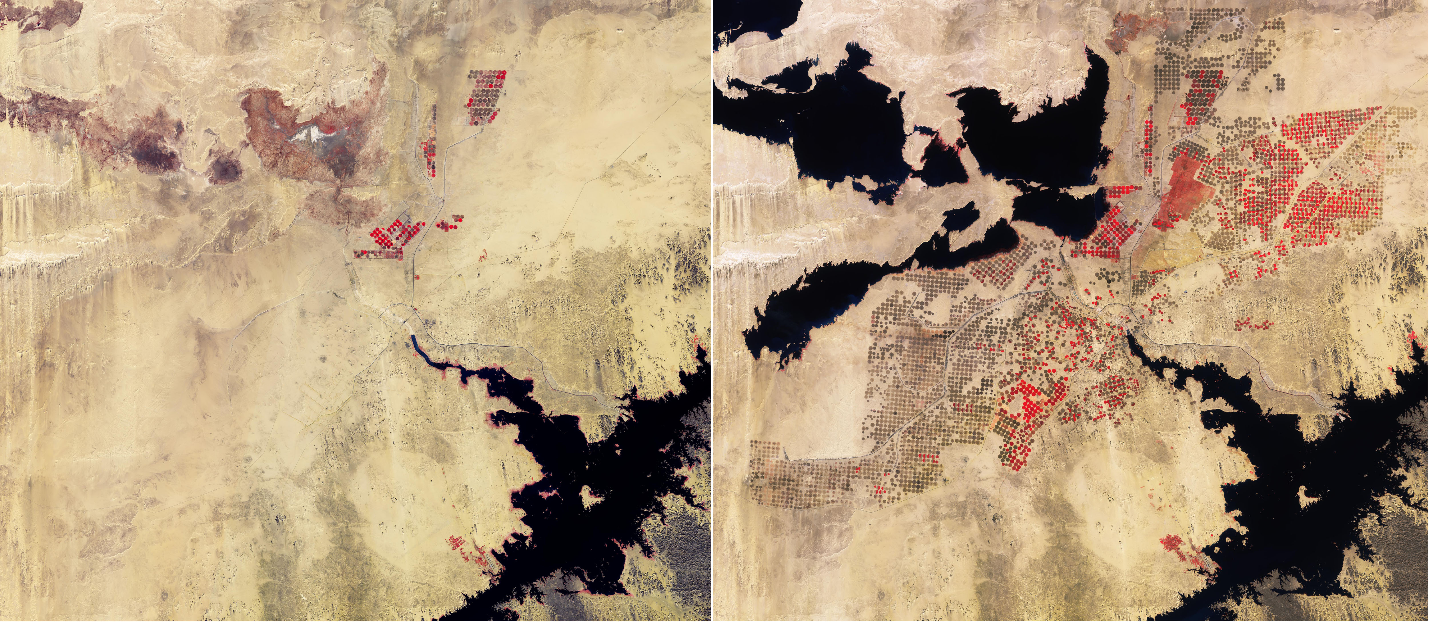
Queste immagini di Copernicus Sentinel-2 mostrano attività agricola nel deserto del sud dell’Egitto, nei pressi del confine con il Sudan.
Oltre il 95% dell’Egitto è costituito da deserto, in effetti una percentuale molto piccola di territorio utilizzabile in agricoltura. Giacchè la domanda di cibo aumenta, è andata crescendo la necessità di realizzare sviluppi agricoli in aree deserte. Il confronto che mostriamo mette in evidenza un importante progetto di bonifica di territorio, in cui il deserto occidentale egiziano viene utilizzato per scopi agricoli e come ciò sia avvenuto tra il 2015 (immagine a sinistra) ed il 2025.
Queste immagini in falsi colori sono state processate utilizzando il canale infrarosso-vicino di Sentinel-2, visualizzando la vegetazione in rosso, in netto contrato con le aree desertiche che caratterizzano la regione. La gamma di colori risultante, dal rosso al marrone, costituisce una rappresentazione più accurata di differenti tipi di vegetazione o differenti stadi di crescita, al confronto con immagini in colori reali.
Pertanto, questi dati satellitari sono utili nel monitoraggio agricolo per mappare e classificare l'uso del suolo, il tipo di coltura, la salute delle colture, il rilevamento dei cambiamenti, la mappatura del paesaggio irrigato e la mappatura delle aree coltivate.
Nelle immagini sono chiaramente visibili i cambiamenti avvenuti nel corso degli ultimi 10 anni. Nel 2015 il paesaggio arido del sud dell'Egitto appariva come un qualsiasi altro deserto. Ma con il tempo la coltivazione della terra è aumentata, trasformando entro il 2025 l'area in terreni agricoli sostenibili.
Le forme dei campi suggeriscono il metodo di irrigazione utilizzato. La maggior parte delle terre coltivate è suddivisa in cerchi, larghi fino a 800 m. Ciò è dovuto al sistema di irrigazione a perno centrale, con l'acqua fornita da un set di irrigatori che ruotano attorno ad un pozzo posto al centro. Poiché nessuna coltura può crescere in questo clima senza un'irrigazione intensiva, i campi sono perfettamente rotondi. Questo tipo di irrigazione aiuta gli agricoltori a gestire le loro necessità idriche ed a preservare risorse preziose.
I canali possono essere visti come sottili linee nere che attraversano i campi agricoli e forniscono acqua dal lago Nasser, visibili in nero in basso a destra. Uno dei più grandi bacini artificiali al mondo, il Lago Nasser è il risultato della costruzione di una diga sulle acque del Nilo e che ha il compito di fornire irrigazione nelle aree vicine.
Negli anni '80 e '90 la deviazione dell'acqua dal Lago Nasser creò i laghi Toshka presenti nell'angolo in alto a sinistra. Questi laghi endoreici sono riempiti dal traboccamento del Lago Nasser attraverso un canale artificiale, chiaramente visibile nell'immagine del 2015, che si snoda all’interno del deserto del Sahara.
Il confronto rivela anche variazioni estreme nei laghi con il trascorrere del tempo. L'ascesa e la discesa dipendono dalle fluttuazioni del flusso d'acqua dal Nilo. Tra il 2012 e il 2018 i laghi si erano notevolmente ridotti, lasciando solo piccoli residui d'acqua nel fondo dei bacini - come appare visibile nel 2015. Le piogge estive in Sudan nel 2019 e le inondazioni record nel 2020 hanno rapidamente rigenerato i laghi, che appaiono completamente pieni nel 2025.
Copernicus Sentinel-2 svolge un ruolo chiave nella mappatura delle differenze nella copertura del suolo allo scopo di comprendere come esso viene utilizzato nel tempo. Mentre fornisce dettagliate informazioni sulla vegetazione terrestre, la missione misura anche la qualità delle acque e rileva modificazioni nei corpi idrici, supportando una gestione dell’acqua sostenibile: una capacità di grande valore per aree aride dove l’acqua è scarsa.
Scarica immagine1 Hi-Res (4,03 MB - .JPG)
Scarica immagine1 Hi-Res (481,94 MB - .TIF)
Scarica immagine2 Hi-Res (3,73 MB - .JPG)
Scarica immagine2 Hi-Res (481,94 MB - .TIF)
---
Desert cropland
These Copernicus Sentinel-2 images show agricultural development in the desert of southern Egypt, close to the border with Sudan.
Egypt is over 95% desert, making a very small proportion of its land suitable for agriculture. As the demand for food grows, the need for agricultural development in desert areas has intensified. This comparison highlights an important land reclamation project, where Egypt’s Western Desert is being used for agriculture, and how it has developed between 2015 (left image) and 2025.
These false-colour images have been processed using Sentinel-2’s near-infrared channel to display vegetation in red – a particularly stark contrast to the desert areas across the region. The resulting range of colours, from red to brown, is a more accurate representation of different types of crop or different growth stages, compared to true-colour images.
Such satellite data are therefore useful in agricultural monitoring for mapping and classifying land use, crop type, crop health, change detection, irrigated landscape mapping and crop area mapping.
Changes over the past 10 years are clearly visible in the images. In 2015, the barren landscape of south Egypt looked like any other desert. But over time, land cultivation has increased, transforming the area into viable agricultural land by 2025.
The shapes of the fields indicate the irrigation method used. Most of the cropland is divided into circles, up to 800 m wide. This is due to the central-pivot irrigation system, with water supplied by a set of sprinklers rotating around a well at the centre. Since no crops can grow in this climate without intensive irrigation, the fields are perfectly round. This type of irrigation helps farmers manage their watering demands and conserve precious resources.
Canals can be seen as thin, black lines cutting through the agricultural fields and supplying water from Lake Nasser, visible in black on the bottom right. One of the largest artificial reservoirs in the world, Lake Nasser is the result of the construction of a dam across the waters of the Nile to provide irrigation in the nearby areas.
In the 1980s and 1990s, the diversion of water from Lake Nasser created the Toshka Lakes featured in the top left corner. These endorheic lakes are filled by overflow from Lake Nasser through a manmade canal, clearly visible in the 2015 image snaking its way into the Sahara Desert.
The comparison also reveals extreme variations in the lakes over time. The rise and fall depend on fluctuations in water flow from the Nile. Between 2012 and 2018, the lakes had shrunk significantly, leaving only small remnants of water in the basins, as visible in 2015. Summer rainfall in Sudan in 2019 and record-breaking floods in 2020 rapidly replenished the lakes, which appear fully filled in 2025.
Copernicus Sentinel-2 plays a key role in mapping differences in land cover to understand how it is used over time. While providing detailed information about Earth’s vegetation, the mission also measures water quality and detects changes in water bodies, supporting sustainable water management – a valuable tool for arid areas where water is scarce.
[Credits: contains modified Copernicus Sentinel data (2015/2025), processed by ESA - Translation: Gianluca Pititto]



