

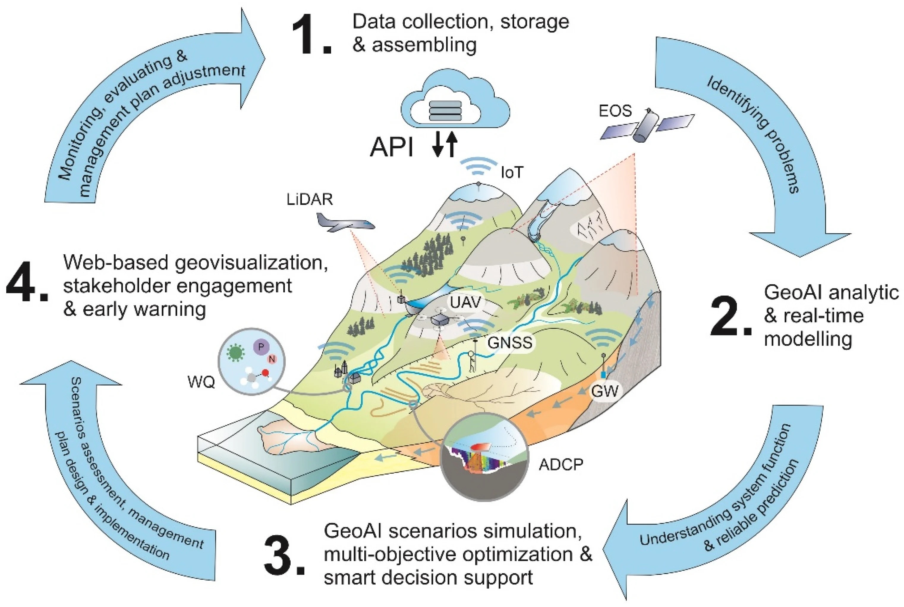
Artificial intelligence is moving deeper into mapping, Earth observation, surveying and digital twins. Ahead of INTERGEO 2026, GEOmedia looks at the transition from individual AI algorithms to intelligent geospatial workflows.
Artificial intelligence has been part of the geospatial technology landscape for years. Machine learning and deep learning are already used for image classification, object detection, feature extraction and the analysis of increasingly large volumes of Earth observation and mapping data. What is changing now is the role AI plays within the geospatial workflow.
The next step is not simply to apply another algorithm to a satellite image or a point cloud. GeoAI is increasingly becoming a layer connecting data acquisition, processing, interpretation and decision-making. This transition will be one of the themes to watch at INTERGEO 2026 in Munich.
From detecting objects to managing workflows
A useful indication of this change comes from the mapping sector itself. A 2026 review published in the International Archives of the Photogrammetry, Remote Sensing and Spatial Information Sciences identifies four established GeoAI application domains within National Mapping Agencies: geospatial data extraction, change detection, 3D point-cloud classification and the standardisation of geographical names.
The same review points to geospatial foundation models and agentic AI as emerging directions. This distinction matters. The first generation of operational GeoAI has largely been about performing a specific task faster: recognising buildings, classifying land cover, identifying changes between images or extracting information from point clouds.
The emerging generation is beginning to address a broader question: can AI understand the objective of a geospatial task and help orchestrate the sequence of operations required to complete it?
That moves GeoAI from individual algorithms towards workflows.
Geospatial agents enter the picture
This is where AI agents become particularly interesting. Geospatial analysis normally requires several steps: identifying the appropriate dataset, accessing it, transforming coordinates or formats, selecting an area of interest, processing raster or vector information, running a model and finally presenting a result that can support a decision.
A 2026 paper presented at the International Workshop on Agentic Engineering describes GeoAIAgent, an architecture designed to orchestrate several of these operations. According to the authors, the framework can use natural-language requests to retrieve and process vector and raster data, interact with geospatial foundation models and return processed results to the user.
The significance is not that domain specialists disappear from the workflow. Quite the opposite. Spatial information retains characteristics that general-purpose AI cannot simply ignore: coordinate reference systems, resolution, topology, positional accuracy, temporal consistency, provenance and uncertainty remain fundamental.
The interesting development is therefore the combination of AI reasoning with geospatial domain knowledge and reliable spatial infrastructures.
INTERGEO 2026 as a test of operational GeoAI
The official INTERGEO 2026 programme offers a particularly revealing example of this direction. On 16 September, the conference includes a dedicated session entitled “Agentic AI Meets Geodata and BIM”, with presentations on Agentic Geo-AI fundamentals, applications for Urban Digital Twins and agents capable of generating building models.
The common denominator is a shift from AI as an analytical tool towards AI as an active component of the geospatial workflow. The programme also places GeoAI in remote sensing and reality-capture workflows alongside BIM, digital twins and data-driven decision processes.
For GEOmedia, Munich will therefore provide a useful benchmark: how much of the agentic-AI discussion has moved from research and demonstrations into repeatable professional workflows?
Foundation models change the scale of the problem
Another important change is the growing role of geospatial foundation models. Instead of training a separate model from scratch for every individual application, foundation models are designed to learn broad representations from large and heterogeneous datasets and then be adapted to multiple downstream tasks.
This approach is especially relevant to Earth observation, where the combination of frequent satellite acquisitions, aerial imagery, UAV data and other geospatial sources produces volumes of information that are difficult to interpret efficiently through conventional processing alone.
The potential is considerable, but so are the technical challenges. Recent research highlights issues such as multimodal alignment, spatial reasoning, distribution shifts and generalisation. In other words, a model that performs well on one geography, sensor or resolution may not automatically transfer to another.
For operational users, this means that model capability must still be assessed together with data quality, spatial context and validation procedures.
GeoAI and digital twins begin to converge
The evolution of GeoAI also helps explain why AI and digital twins are increasingly discussed together.
A digital twin requires continuous connections between the physical environment and its digital representation. Reality capture, GNSS, Earth observation, IoT and GIS provide observations. AI can help classify, interpret and prioritise those observations.
Agentic systems potentially add another layer: selecting which data and processes are needed to answer a particular operational question, and coordinating some of the steps required to produce the answer.
The result is no longer simply a better map or a more detailed 3D model. It is the possibility of creating a more intelligent geospatial workflow in which data acquisition, interpretation and decision support become progressively more connected.
From maps to urban decisions
The implications extend beyond the traditional geospatial industry. A 2026 GeoAI toolkit developed by ICLEI in collaboration with UN-Habitat and UNITAC focuses specifically on the integration of GeoAI into urban planning and management workflows.
The toolkit emphasises both opportunities and constraints. GeoAI can support spatially informed planning, infrastructure investment and service delivery, but its responsible adoption also depends on skills, data quality, digital infrastructure, privacy, security and the management of algorithmic bias.
This is an important reminder for the geospatial sector: AI does not remove the need for good data governance. As GeoAI becomes more deeply embedded in public and professional workflows, trustworthy data and trustworthy AI become part of the same operational problem.
What to watch in Munich
For GEOmedia, the interesting question at INTERGEO 2026 will therefore not be how many exhibitors attach the letters “AI” to their products. It will be where AI actually changes the geospatial production chain.
Can an AI system understand spatial context? Can it combine information from different sensors and epochs? Can it operate while preserving accuracy, provenance and uncertainty? Can it interact reliably with GIS, BIM and digital twins? And, perhaps most importantly, can organisations move these technologies from demonstrations into repeatable operational processes?
These questions also bring governance into the discussion. The 2026 review of GeoAI in National Mapping Agencies explicitly identifies explainability, bias and geoprivacy among the issues that organisations need to address when introducing AI into production environments.
The transition from experimentation to operational GeoAI is therefore not simply a matter of deploying larger models. It requires good geospatial data, domain expertise, interoperable systems, validation and trustworthy AI.
That is precisely why INTERGEO is an interesting place to observe what happens next.
GEOmedia will be in Munich from 15 to 17 September 2026, following the technologies, companies and applications turning GeoAI from an experimental capability into part of the geospatial workflow.
Sources
- Didouz, Z., Sebari, I., Ait El Kadi, K. – The Use of Geospatial Artificial Intelligence Technologies (GeoAI) within National Mapping Agencies: A Review, ISPRS Archives, 2026.
- Tizzei et al. – GeoAIAgent: Agentic workflow for automated geospatial data management, Proceedings of AGENT '26, ACM, 2026.
- INTERGEO Conference 2026 – Official programme.
- AI for Spatial Mapping and Analysis – GeoAI Toolkit for Urban Planners, ICLEI / UN-Habitat / UNITAC, 2026.
This article is part of GEOmedia's Road to INTERGEO 2026. Follow our international coverage, get your free visitor ticket and meet GEOmedia in Munich.
EXPLORE GEOmedia AT INTERGEO 2026 →


