

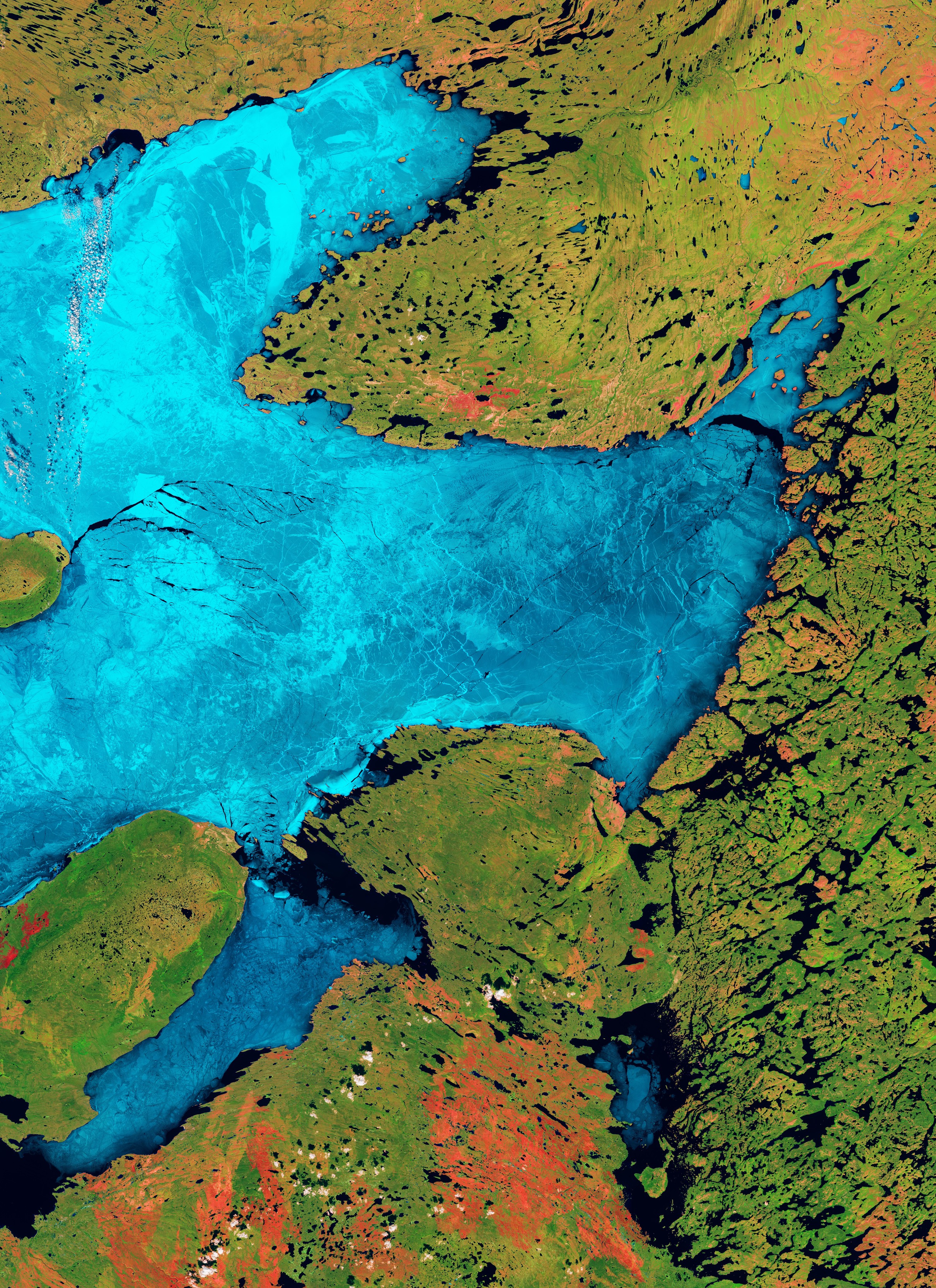
La missione Copernicus Sentinel-2 mostra con colori appariscenti il lago del Grande Orso, in Canada.
A cavallo del Circolo Polare Artico, il lago del Grande Orso si trova nei Territori del Nord-Ovest del Canada. La sua superficie di 31.328 km² lo rende il più grande lago d'acqua dolce interamente all'interno dei confini canadesi e il quarto più grande del Nord America.
Di forma irregolare e contenente molte piccole isole, il lago del Grande Orso è circondato da foreste boreali e tundra ed offre un habitat ricco per una fauna diversificata. È famoso per le sue acque fredde e limpide, che sono coperte di ghiaccio dalla fine di novembre fino a luglio.
La presenza di ghiaccio lacustre può essere monitorata efficacemente da sensori ad immagini ed osservazioni satellitari standard. Per la elaborazione di questa immagine a falsi colori sono state utilizzate tre bande specifiche provenienti dai canali visibile ed infrarosso di Copernicus Sentinel-2. Ad ogni canale è stato assegnato un colore per aumentare il contrasto tra le diverse superfici. Questa combinazione di bande è particolarmente adatta per monitorare lo scioglimento del ghiaccio, i corpi idrici e lo stato di salute della vegetazione.
Un enorme strato di ghiaccio marino che copre la maggior parte del lago può essere osservato in tonalità che vanno dal blu brillante al ciano, a seconda dello spessore del ghiaccio. Questa gamma di colori è dovuta al fatto che ghiaccio e neve hanno una riflettanza più elevata nella parte visibile dello spettro, qui assegnata al blu. L'immagine, catturata il 17 giugno 2026, mostra una rete intricata di fratture stagionali, crepe e banchi di ghiaccio che si muovono sulla superficie del lago.
Poiché l'acqua riflette pochissima radiazione verso il satellite, essa appare blu scuro o nero, rendendo facili distinguere le aree di ghiaccio fuso. Queste aree scure sono tipicamente visibili lungo le rive e nelle baie, dove le acque più basse si riscaldano più rapidamente rispetto al centro del lago che è più profondo, creando un fossato limpido di acqua priva di ghiaccio tra la terra e la restante calotta glaciale. Sulla superficie ghiacciata possono anche essere osservate fratture nere di acque aperte.
Sfumature di verde dominano la massa terrestre che circonda il lago, stando ad indicare la foresta boreale settentrionale e la vegetazione della tundra, che si inverdiscono con l'avvicinarsi dell'estate artica.
Macchie distinte di colore rosso-arancio e rosa sono sparse sul paesaggio verde, indicando un terreno roccioso esposto, tipico della Calotta Canadese, tundra scarsamente vegetata o cicatrici più antiche da incendi che non si sono ancora completamente rivegetate.
La missione Copernicus Sentinel-2 è formata da una costellazione di due satelliti. Ogni satellite trasporta una telecamera ad alta risoluzione che riprende la superficie terrestre in 13 bande spettrali. Questa capacità, insieme sia ai frequenti transiti della missione sulla stessa area e sia alle sue immagini ad alta risoluzione, fornisce informazioni cruciali sulle condizioni della Terra: come l'uso del suolo, lo stato di salute della vegetazione ed i cambiamenti nei corpi idrici interni e nell'ambiente costiero.
Scarica immagine Hi-Res (21,37 MB - .JPG)
Scarica immagine Hi-Res (369,32 GB - .TIF)
---
Great Bear Lake, Canada
The Copernicus Sentinel-2 mission captures Canada’s Great Bear Lake in striking colours.
Straddling the Arctic Circle, Great Bear Lake lies in the Northwest Territories of Canada. Its area of 31 328 sq km makes it the largest freshwater lake entirely within Canadian borders and the fourth largest in North America.
Irregular in shape and containing many small islands, Great Bear Lake is surrounded by boreal forests and tundra, providing a rich habitat for diverse wildlife. It’s famous for its cold, clear waters, which are covered with ice from late November through to July.
The presence of lake ice can be monitored effectively by imaging sensors and standard satellite observations. In this false-colour image, three specific bands from Copernicus Sentinel-2’s visible and infrared channels have been used to process the image. Each channel has been assigned a colour to enhance the contrasts between different surfaces. This band combination is particularly suitable for monitoring ice melt, water bodies and vegetation health.
A massive sheet of sea ice covering most of the lake can be seen in shades ranging from bright blue to cyan, depending on the ice thickness. This range of colours is due to ice and snow having a higher reflectance in the visible part of the spectrum, here assigned to blue. The image, which was captured on 17 June 2026, features an intricate network of seasonal fractures, cracks and shifting ice floes across the lake surface.
Because water reflects very little light back to the satellite, it appears dark blue or black, making areas of melted ice easy to distinguish. These dark areas are typically visible along the shorelines and in the bays, where shallower water warms more quickly than the deeper centre of the lake, creating a clear moat of ice-free water between the land and the remaining ice sheet. Black fractures of open water can also be seen in the icy surface.
Shades of green dominate the landmass surrounding the lake denoting the northern boreal forest and the tundra vegetation, greening as the Arctic summer approaches.
Distinct reddish-orange and pink patches are scattered across the green landscape, indicating exposed rocky terrain, typical of the Canadian Shield, sparsely vegetated tundra or older fire scars that have not yet fully revegetated.
The Copernicus Sentinel-2 mission is based on a two-satellite constellation. Each satellite carries a high-resolution camera that images Earth’s surface in 13 spectral bands. This capability, together with the mission’s frequent revisits over the same area and its high-resolution imagery, provides crucial information about the conditions on Earth, such as land use, vegetation health, and changes in inland water bodies and the coastal environment.
[Credits: contains modified Copernicus Sentinel data (2026), processed by ESA - Translation: Gianluca Pititto]



