

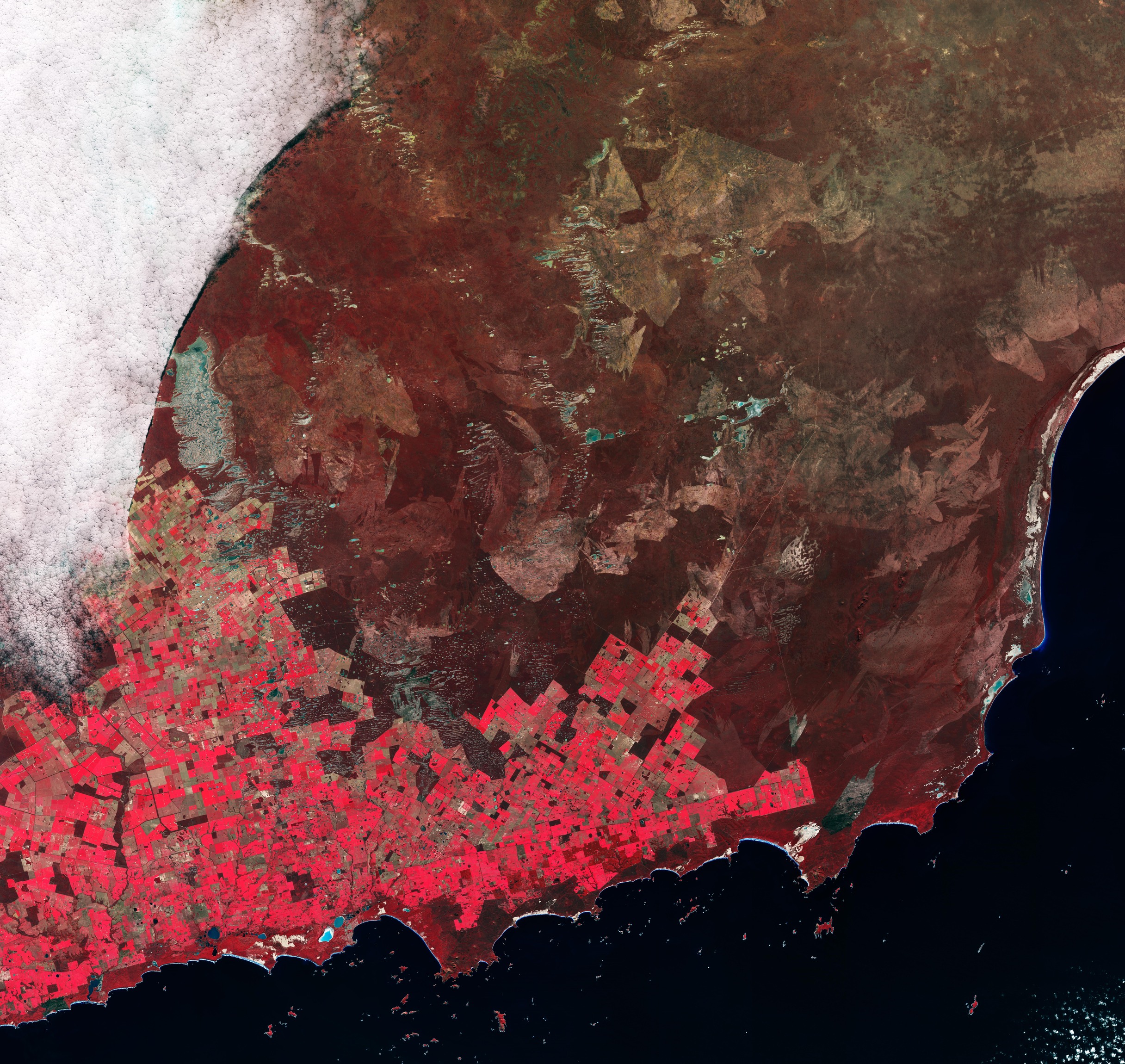
La missione Copernicus Sentinel-2 ci porta sull'angolo sud-ovest dell'Australia nella regione Goldfields–Esperance dell'Australia Occidentale, qui osservata nel giugno 2026.
Goldfields–Esperance è la più grande delle regioni dell'Australia Occidentale. I terreni sono generalmente piuttosto salini ed il clima è per lo più caldo e secco, di regola con basse precipitazioni annuali, ad eccezione della piccola area più umida intorno alla città di Esperance, mostrata in questa immagine.
I colori sono stati ottenuti elaborando l'immagine includendo anche il canale nel vicino infrarosso di Sentinel-2, che mette in risalto la vegetazione in rosso ed aiuta ad evidenziare diverse informazioni rispetto ad un'immagine in colori naturali.
I campi agricoli creano un mosaico colorato di forme geometriche che dominano la parte in basso a sinistra dell'immagine. I colori variano dal rosso al marrone, permettendo una migliore distinzione tra i diversi tipi di vegetazione. Questa particolarità è quindi utile quando i dati Sentinel-2 vengono utilizzati nel monitoraggio agricolo per mappare e classificare l'uso del suolo, il tipo di coltura, la salute delle colture, il rilevamento dei cambiamenti, la mappatura del paesaggio irrigato e la mappatura delle aree coltivate.
Le isole che formano l'arcipelago di Recherche possono essere facilmente individuate al largo della costa come puntini rossi sparsi nelle acque scure dell'oceano meridionale. Conosciuta anche come la Baia delle Isole, quest'area si estende per 230 km ed è una riserva naturale protetta, famosa per le sue acque turchesi limpide e la ricca vita marina.
Nell’immagine sono visibili diversi laghi salati di diverse dimensioni, in colori che vanno dal blu al verde, a seconda della loro salinità e della profondità dell'acqua. Il più grande che si vede qui è il Lago Dundas, situato a nord dei campi, appena ad ovest del fronte di nuvole bianche. Questo lago incrostato di sale ha un contorno altamente irregolare, con isole che punteggiano le sue acque verdastre.
La costa dell'Australia Occidentale è anche punteggiata da numerosi altri laghi salati, tra cui i laghi Warden e Pink – i due corpi idrici bluastri uno accanto all'altro vicino al centro dell'immagine.
Il lago Pink, il bacino bianco e azzurro a sinistra, era famoso per la tonalità rosa delle sue acque grazie ad una miscela di alte concentrazioni di sale ed alghe che prosperavano sul sale. Ai nostri giorni i cambiamenti nella salinità hanno fatto perdere al lago il suo colore iconico. Il lago Warden è una riserva naturale protetta, riconosciuta come sistema Ramsar di zone umide di importanza internazionale. Nonostante sia molto salato, il bacino lacustre offre un habitat per migliaia di specie di uccelli acquatici.
La città di Esperance, che dà anche il nome all'intera regione, si può riconoscere sulla baia a 3 km ad est del lago Pinde. Circondata da cinque grandi parchi nazionali, Esperance ospita splendide spiagge di sabbia bianca ed è l'unico porto nel sud-est dell'Australia occidentale.
Scarica immagine Hi-Res (10,73 MB - .JPG)
Scarica immagine Hi-Res (256,13 GB - .TIF)
---
Agricultural patchwork
The Copernicus Sentinel-2 mission takes us over Australia’s southwestern corner in the Goldfields–Esperance region of Western Australia, seen here in June 2026.
Goldfields–Esperance is the largest of Western Australia's regions. The soils are generally quite saline and the climate is mostly hot and dry with typically low annual rainfall, except for the small wetter area around the town of Esperance pictured here.
The colours in this image are created by processing the image including Sentinel-2’s near-infrared channel, which highlights vegetation in red and helps to reveal different information compared to a natural colour image.
Agricultural fields create a colourful patchwork of geometric shapes dominating the lower-left part of the image. The colours range from red to brown, allowing for better discrimination between different types of vegetation. This feature is therefore helpful when Sentinel-2 data are used in agricultural monitoring for mapping and classifying land use, crop type, crop health, change detection, irrigated landscape mapping and crop area mapping.
The islands forming the Recherche Archipelago can also be easily spotted off the coast as red dots scattered in the dark Southern Ocean water. Also known as the Bay of Isles, this area spans 230 km and is a protected nature reserve, famous for its clear turquoise waters and rich marine life.
Several salt lakes of different sizes are visible across the image in colours ranging from blue to green, depending on their salinity and water depth. The largest seen here is Lake Dundas, lying north of the fields, just west of the white cloud front. This salt-encrusted lake has a highly irregular outline with islands speckling its greenish waters.
The coastline of Western Australia is also dotted with multiple salt lakes, including Lake Warden and Pink Lake – the two blueish water bodies next to each other near the centre of the image.
Pink Lake, the white and azure basin on the left, was famous for the pink hue of its water owing to a mix of high salt concentrations and algae thriving on the salt. Today, changes in salinity have caused the lake to lose its iconic colour. Lake Warden is a protected nature reserve recognised as a Ramsar wetland system of international importance. Despite being very salty, the lake basin offers a habitat for thousands of species of waterbird.
The town of Esperance, which also gives its name to the region, can be seen on the bay 3 km east of Pink Lake. Surrounded by five major national parks, Esperance is home to stunning white sand beaches and is the only port in the southeast of Western Australia.
[Credits: contains modified Copernicus Sentinel data (2026), processed by ESA - Translation: Gianluca Pititto]



