

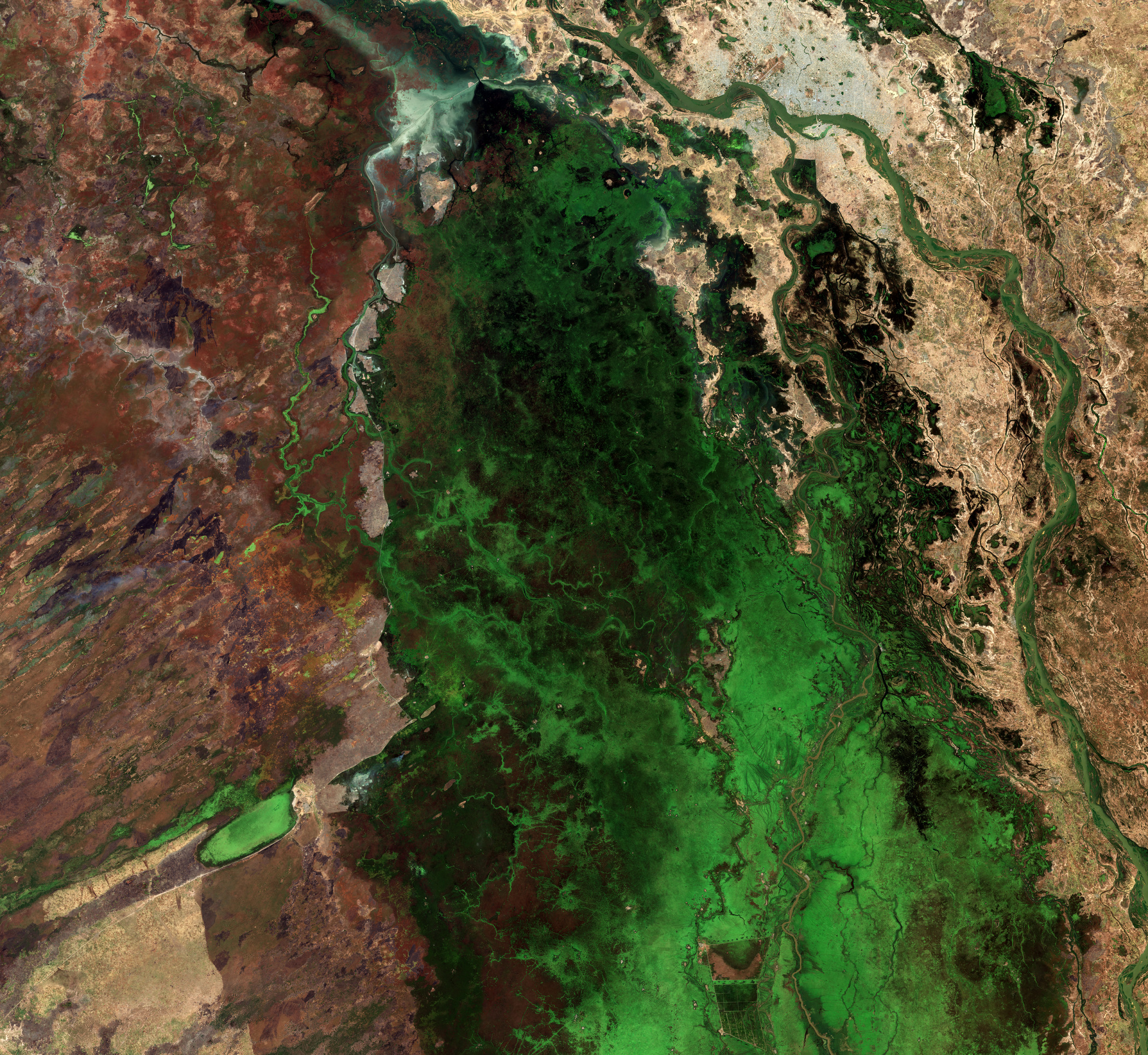
La missione Copernicus Sentinel-2 cattura il suggestivo paesaggio che circonda il Parco Nazionale di Waza in Camerun.
Il Parco Nazionale di Waza si trova nella regione più settentrionale del Camerun che si estende tra il Ciad ad est e la Nigeria ad ovest: copre un'area di 1700 kmq e dista solo circa 10 km dal confine di ognuno dei paesi.
Il parco si trova sul lato sinistro dell'area verde nella parte inferiore dell'immagine. È la riserva faunistica con più diversità del paese ed ospita leoni, elefanti, giraffe, antilopi e numerose specie di uccelli. È stata dichiarata nel 1979 Riserva della Biosfera Patrimonio dell'Umanità dall'Unesco.
In corrispondenza del suo perimetro occidentale si trova la città di Waza, visibile come una piccola area giallastra fiancheggiata su due lati da terra verde.
La vasta zona verde che circonda il parco è la pianura alluvionale del Logone, una delle numerose pianure alluvionali all'interno del bacino del Lago Ciad. Il verde lussureggiante nell'immagine è il risultato delle inondazioni stagionali del fiume Logone, il quale appare come una tortuosa linea marrone ad est della pianura e scorre lungo il confine tra Camerun e Ciad.
L'ecosistema di questo territorio è modellato dal ciclo delle stagioni secche e umide. Durante la stagione delle piogge, che dura da metà maggio a metà ottobre, la regione è inondata, diventando una zona umida temporanea che permette lo sviluppo di erbe, canneti e corpi idrici stagionali.
Più di 100.000 persone vivono nella zona e dipendono dalle tempistiche e dall'entità dell'alluvione per la pesca, il pascolo e l'agricoltura. Nell'immagine sono visibili apezzamenti di campi agricoli, con il più grande in fondo a sinistra del fiume Logone.
Questa immagine è stata acquisita nel novembre 2024, quando le acque alluvionali di solito iniziano a ritirarsi, lasciando l'area verde e fertile. Sono già visibili segnali dell'arrivo della stagione secca: mentre il parco conserva la vegetazione naturale, i terreni vicini si spostano verso stoppie post-raccolta o campi incolti, che appaiono in tonalità marroni.
Sulla destra, il fiume Chari - il principale affluente del lago Ciad - appare di colore verde. Si unisce al fiume Logone a nord, prima di sfociare più a nord nel lago Ciad (punto non visibile nella foto). Alla confluenza tra Chari e Logone si trova N'Djamena, la capitale del Ciad, visibile come una grande area grigia nella parte superiore dell'immagine.
Scarica immagine HiRes (39,29 MB - .JPG)
Scarica immagine HiRes (526,17 MB - .TIF)
---
Waza National Park, Cameroon
The Copernicus Sentinel-2 mission captures the striking landscape surrounding the Waza National Park in Cameroon.
The Waza National Park lies in the most northern region of Cameroon extending between Chad to the east, and Nigeria in the west. The park, which covers an area of 1700 sq km, is only about 10 km from the border of each country.
Here, the Waza National Park is on the left side of the green area at the bottom of the image. It is the country’s most diverse wildlife reserve and is home to lions, elephants, giraffes, antelopes and numerous species of birds. It was declared a Unesco World Heritage biosphere reserve in 1979.
At its western perimeter lies the town of Waza, visible as a small, yellowish area flanked by green land on two sides.
The vast, green zone surrounding the park is the Logone floodplain, one of the numerous floodplains within the Lake Chad basin. The lush green in the image is the result of seasonal flooding of the Logone River, appearing as a winding brown line to the east of the plain, and flowing along the border between Cameroon and Chad.
The ecosystem of this territory is shaped by the cycle of dry and wet seasons. During rainy season, which lasts from mid-May to mid-October, the region is inundated, becoming a temporary wetland that sustains grasses, reeds and seasonal water bodies.
More than 100 000 people live in the area and rely on the timing and the extent of the flood for fishing, grazing and agriculture. Patches of agricultural fields are visible in the image, with the largest at the bottom, left of the Logone River.
This image was acquired in November 2024, when the floodwaters usually start receding, leaving the area green and fertile. Evidence of the coming dry season is already visible: while the park conserves natural vegetation, nearby lands shift towards post-harvest stubble or fallow fields, appearing in brown hues.
On the right, the Chari River, Lake Chad’s principal tributary, appears green. It joins the Logone River to the north, before eventually flowing into Lake Chad (not pictured) further north. At the confluence between Chari and Logone lies N’Djamena, the capital city of Chad, visible as a large grey area at the top of the image.
[Credits: contains modified Copernicus Sentinel data (2024), processed by ESA - Translation: Gianluca Pititto]
